The Cachuma Resource Conservation District’s (CRCD) Regional Priority Plan (RPP) project was funded by the California Coastal Conservancy to identify projects and produce mapping results that will help Santa Barbara County proactively address the ongoing threat of wildfires in the region. The CRCD is conducting this multi-prong effort to collect/collate data and collaborate with a focus on public and private land in the wildland/urban interface (WUI). The RPP will help with the planning, mapping and prioritization of projects with the goal of reducing wildfire risk and improving forest and habitat health. It began in spring of 2020, right at the beginning of the pandemic, with a series of Zoom interviews with various members of the community, including fire personnel, educators, community members, governmental jurisdictions, and several non-profits. Through these interviews, project concepts materialized to help support fire resilience efforts in all of Santa Barbara County. The RPP will likely be released in late summer of 2021, and will include a suite of potential projects and partners, as well as a map database that can be used to assess fire risk at the landscape level.
The end result of this 1 year project will be to develop a set of tools to help coordinate and support everyone’s efforts – including a decision support mapping tool to identify gaps, needs and priority projects for the region. Ultimately, CRCD hopes this will lead to a better coordinated, regional approach to fire resilience and habitat health via future actions and demonstration projects that will foster this vision in a proactive fashion
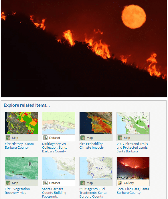
A sophisticated mapping tool is being used to predict high fire-risk areas as a basis for identifying areas of specific concern at the landscape level. CRCD hopes to build on work and projects already underway, identify additional needs beyond those typically addressed in a Community Wildfire Protection Plan (CWPP) to support fire protection efforts, and to provide a community resource using the Conservation Blueprint Atlas as a repository of maps and other related information (such as a network map of key partners for project concepts). The portal created for the Conservation Blueprint Atlas contains a collection of the most up-to-date information available regarding fire protection in Santa Barbara County. In addition to collecting the existing CWPPs, other data was added to provide a “one stop” information portal for the fire community. The RPP should improve communication and network building in the County and help set community priorities. Potential priority projects and GIS data layers are currently being collected and stored in the Conservation Blueprint through conversations with experts and stakeholders.
The Atlas is an amazing database that can be used for a multitude of needs in the community. For example, it can be used to share work among a team of people, or to share information with the public about a topic of interest. It is a freely accessible tool to anyone, and can be used for interesting land analysis, storing data, and teaching. More people should be aware that it exists, so the Conservation Blueprint team is conducting outreach to help spread the word about how it can be used. These outreach efforts can include a brief training on how it can work for a specific need or to introduce all the potential ways the Conservation Blueprint can serve the community.
 For more information, contact:
Anna Olsen
Executive Director
Cachuma Resource Conservation District
(805) 868-4013 | aolsen@rcdsantabarbara.org
Christina McGinnis
McGinnis Environmental
(805) 452-3985 | mcginnisenv@gmail.com